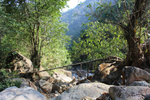
MAWLAM 2

IMG_1957

RIVER/STREAM: WAH MYNSAW
GPS: N25.26278 E91.84214
ALTITUDE: 455 m
NOTES: A root bridge once existed in this location. It was mostly destroyed in a landslide, though a small part of it, pictured above, remains. This was the root bridge that serviced the same path as MAWLAM 3. The two living root bridges are only about 30 m apart.
NOTE: PLEASE GO TO ANALYTICS AND ANALYSIS (APRIL 2017 DRAFT) FOR METHODOLOGIES. LR PROJECT DESIGNATION DOES NOT REFLECT LOCAL NAME.

Leave a Reply

Fill in your details below or click an icon to log in:

WordPress.com Logo

You are commenting using your WordPress.com account. Log Out /  Change )

Google photo

You are commenting using your Google account. Log Out /  Change )

Twitter picture

You are commenting using your Twitter account. Log Out /  Change )

Facebook photo

You are commenting using your Facebook account. Log Out /  Change )

Connecting to %s