
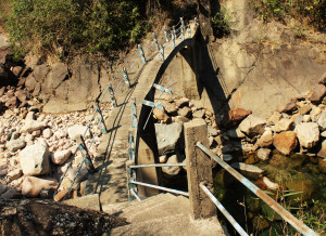
| RIVER/STREAM: | WEIKYNMEI |
| GPS: | N25.27183 E91.60836 |
| ALTITUDE: | 321 m |
| NOTES: | A root bridge existed at this position until around 2009, when it was destroyed in a flood. Pictured is the root bridge’s conventional replacement. Note that the replacement bridge has already been significantly damaged by flooding. The root bridge would have been in the vicinity of 30 m long. |
NOTE: PLEASE GO TO ANALYTICS AND ANALYSIS (APRIL 2017 DRAFT) FOR METHODOLOGIES. LR PROJECT DESIGNATION DOES NOT REFLECT LOCAL NAME.
