
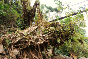
| RIVER/STREAM: | PHUD UMBLAI |
| GPS: | N25.28699 E91.64449 |
| ALTITUDE: | 461 m |
| NOTES: | A very large root bridge existed in this location until recently. It was said to have been destroyed in a landslide. Pictured above is a remnant of the span. The replacement bridge, as visible in background of the photo, is 30 m long. The root bridge would have been slightly longer, though also a few meters lower. |
NOTE: PLEASE GO TO ANALYTICS AND ANALYSIS (APRIL 2017 DRAFT) FOR METHODOLOGIES. LR PROJECT DESIGNATION DOES NOT REFLECT LOCAL NAME.

Remnants of a living root bridge in the foreground, a long steel replacement bridge in the background.

Looking down at the remnants of the root bride from the steel bridge.
