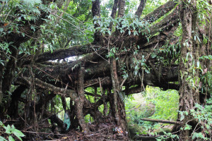
MAWKLIAW 1

IMG_2490

RIVER/STREAM: WAH SHARI
LENGTH: 12.8 m
WIDTH AT CP: 1.2 m
HEIGHT AT CP: 2.7 m
GPS: N25.22774 E91.81338
ALTITUDE: 835 m
SR: 2
NOTES: A small root bridge with ubiquitous latex extraction damage near Mawkliaw village. The roots are exceptionally thick, but are almost entirely covered with cuts. Large parts of the tree were observed to be rotting. The path the bridge services is said to still be in occasional use, though there were no indications of recent maintenance.
NOTE: PLEASE GO TO ANALYTICS AND ANALYSIS (APRIL 2017 DRAFT) FOR METHODOLOGIES. LR PROJECT DESIGNATION DOES NOT REFLECT LOCAL NAME.

Leave a Reply

Fill in your details below or click an icon to log in:

WordPress.com Logo

You are commenting using your WordPress.com account. Log Out / Change )

Twitter picture

You are commenting using your Twitter account. Log Out / Change )

Facebook photo

You are commenting using your Facebook account. Log Out / Change )

Google+ photo

You are commenting using your Google+ account. Log Out / Change )

Connecting to %s