
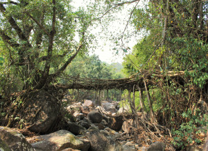
| RIVER/STREAM: | USTEM |
| LENGTH: | 11.8 m |
| WIDTH AT CP: | .9 m |
| HEIGHT AT CP: | 6 m |
| GPS: | N25.23270 E91.76888 |
| ALTITUDE: | 307 m |
| SR: | 7 |
| NOTES: | A short distance downstream from Laitiam 1. Older, with thicker and sturdier roots. Structurally sound, but with very minor latex extraction damage. The Laitiam village council has outlawed any damage to the bridge. The bridge leads to an island in the middle of the Ustem. Another bridge was attempted, using the same tree, from the island to the other side of the stream, but was destroyed by flooding before it became operational. This means that the living root bridge does not cross the whole stream, and for this reason is used less than Laitiam 1, limiting the amount of community involvement. |
NOTE: PLEASE GO TO ANALYTICS AND ANALYSIS (APRIL 2017 DRAFT) FOR METHODOLOGIES. LR PROJECT DESIGNATION DOES NOT REFLECT LOCAL NAME.
