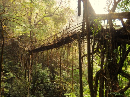
INTRODUCTION
The following is my interpretation of the information I collected on 88 living root structures in the state of Meghalaya in 2016. For standing living root bridges, I attempted to measure the length, width, and height of each structure, and to determine its GPS position. Using the GPS coordinates, I later ascertained the approximate altitude of each structure using Google Earth. I also sought to gather as much historical information about each structure as possible and to gauge the level of threat posed to each root bridge by natural and manmade factors. The designations employed in this survey refer to the village that any given structure was (probably) made by, followed by the order in which the structure was visited as part of the project. They do not reflect local names.
The total number of standing living root bridges included in this survey is 53. The northernmost, designated Kongthong 2, is located at N25.34485, E91.82443. The southernmost, designated Darrang 1, is located at N25.20516, E92.01889. The westernmost, designated Nongsteng/Nongbah 1, is located at N25.27790, E91.62988. The easternmost, designated Kudeng Rim 5, is located at N25.22664, E92.03979. The existence of other standing living root structures beyond these points in any direction is highly likely.
The number of failed living root bridges included in this survey is 24, and they fall into two general categories. Where the span has fallen but the tree that is was formed from still exists, there are often very definite physical remnants of the bridge to be found. The GPS coordinates and altitude of these structures can easily be determined. In other cases, both the tree and the bridge have disappeared entirely, and the only indication of their having existed comes from the memories of local villagers. There are only a few cases where there was enough information to ascertain the exact location of these entirely disappeared structures.
I have been as conservative as possible in creating listings for destroyed living root bridges. Given the lack of historical records, information on these disappeared structures depends on personal recollections and is therefore often conflicting and imprecise. For example, in the village of Suktia, one source claimed that there used to be four living root bridges on the village’s land, another claimed there were once six, and yet another claimed there were once ten. No remnants could be found while I was there, nor could the exact position of any of these former living root bridges be pin-pointed. Therefore, while my information does point to the past existence of a great number of living root bridges in the area, as they cannot be exactly located no listings have been created.
Additionally, I came across many locations where there were old, clearly planted, fig trees growing on the opposite sides of river banks directly across from one another. While these often appeared as though they were once the locations of living root bridges, without direct confirm from several locals (ideally from different villages), I did not include these locations in the study, even if, judging solely from the visual evidence, it seems very likely that living root bridges did exist there once.
It should be noted that, were I to include all the “possible” former living root bridges, the number of failed living root bridges would increase by a large margin.
This survey also includes ten miscellaneous structures made from ficus elastica roots which are not bridges. These include ladders, ramps, platforms, hybrid steel and root structures, and a point where a new living root bridge is being planned. It also includes two places where there were once living root ladders, which have been torn down and replaced with conventional structures. One living root structure, designated Kongthong 1, has most of the measurable characteristics of a living root bridge, but is more accurately classed as a ramp than as a bridge, as it does not directly cross a stream. The data from that structure is grouped with the data on living root bridges.
When it comes to measurements, it is very difficult to be exact for the simple reason that, rather than being conventional structures that are assembled from pre-fabricated components, root bridges are the result of organic processes. To add to this is the fact that many of the root bridges included in this study were visited under difficult physical circumstances, often in inclement weather, with limited time and a bare minimum of equipment. Later attempts at measuring the same structures where the individuals involved have more time, resources, and possibly improved methodologies, might come up with slightly different results.
I take full responsibility in advance for any mistakes that can be found in the information listed below.
LENGTH:
For the purposes of this study, the length of a living root bridge is defined as the distance over which a person crossing the bridge will be suspended above the ground solely by the structure itself. I have tried to ascertain this distance by first locating the point at which the structure leaves the ground on one side of a river bank, then finding the place at which it reconnects on the opposite side, and determining the distance between these two points. The exact points are not always entirely clear, and might differ slightly from the right and left sides of the bridge. Additionally, it is worth noting that there are often planned, planted, components which are structurally integral to a given root bridge which are not part of the actual span of the bridge. These have not been measured.
In the instances of double root bridges with two independent spans, each span has been measured separately.
Figures are in meters and are rounded to the nearest decimal place.
NUMBER OF SPANS MEASURED: 54
AVERAGE SPAN LENGTH: 18.3 m
LONGEST SPAN: 52.7 m (Rangthylliang 12)
SHORTEST SPAN: 4.8 m (Rangthylliang 3)
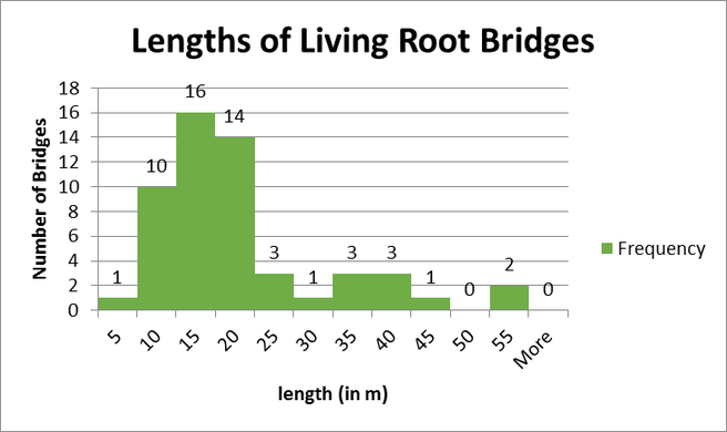
Note that 41 of 54, or slightly over 75%, of root bridges included in this study are 20 m or less, with frequencies above 20 m falling off sharply. This is in line with anecdotal information I’ve received from villagers stating that the longer a living root bridge is, the more difficult it is to maintain, and the more susceptible it will be to environmental hazards.
Interestingly, the graph above shows that there are close to five times as many bridges that are between 15 and 20 meters in length as are between 20 and 25. If this pronounced drop is still visible with the addition of significantly more entries, it may indicate a particular length at which growing living root bridges becomes decidedly more difficult.
WIDTH:
For the purposes of this study, the width of a living root bridge is defined as the distance between the furthest left and furthest right element of the bridge at its span’s central point (CP). The central point is defined as the location on the span that marks one half of the length measurement. The width is not solely a measurement of the walkway of the bridge, and where applicable includes railings, and sometimes other roots, found at the CP that do not take significant stresses.
In the instances of double root bridges with two independent spans, each span has been measured separately.
Figures are in meters and are rounded to the nearest decimal place.
NUMBER OF SPANS MEASURED: 53
AVERAGE SPAN WIDTH: 1.3 m
WIDEST SPAN: 2.4 m (Rangthylliang 3)
NARROWEST SPAN: 0.7 (3 bridges are tied for narrowest: Rymmai 1, Diengsiar 1, and Kudeng Rim 1).
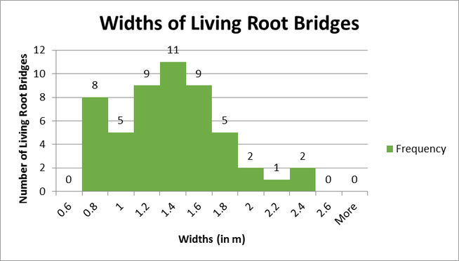
The date above includes all of the widths that could be measured in this survey, including those which have non-root functional elements, or that have sustained severe damage. All three bridges that are measured at .7 m are bridges that are fragments of larger structures or that have had their spans badly damaged.
WIDTH (ADJUSTED):
The following is an interpretation of the width data adjusted to exclude measurements of root bridges with significant non-root elements and those that have had their widths narrowed by damage.
NUMBER OF SPANS MEASURED: 42
AVERAGE SPAN WIDTH: 1.4 m
WIDEST SPAN: 2.4 m (Rangthylliang 3)
NARROWEST SPAN: 0.8 m (3 bridges are tied: Nongpriang 3, Mawlam 3 (lower span), Tyrngei 1, Rangthylliang/Mawkyrnot 1)
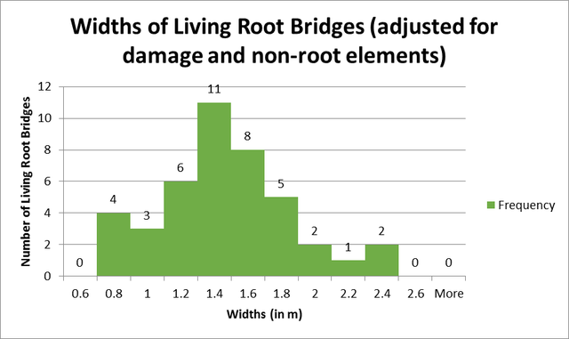
If corrected for damage and non-root elements, the average width increases somewhat, and the relatively high frequency of bridges in the range of 0.6 and 0.8 m in width is significantly lessened. This indicates that, under ideal conditions, root bridges tend to fall between 1 and 1.8 m in width.
Note that the widths of two unusually wide root bridges (Nongbah/Mawshuit 1 and Kudeng Rim 5) could not be measured due to hazardous conditions.
HEIGHT:
For the purposes of this survey, the height of a living root bridge is defined as the distance from the lowest part of the central point (CP) of the bridge’s span, to the ground, stream bed, or water surface, below. The central point is defined as the location on the span that marks one half of the length measurement.
It should be noted that height measurements taken from different points on a given living root bridge could vary widely. This is because A: Living root bridges are often sloping in layout and B: the water bodies root bridges cross, being mountain streams, also frequently slope and are usually rocky, rarely presenting even surfaces.
In the instances of double root bridges with two independent spans, each span has been measured separately.
Figures are in meters and are rounded to the nearest decimal place.
NUMBER OF SPAN-HEIGHTS MEASURED: 54
AVERAGE SPAN HEIGHT: 6.2 m
HIGHEST SPAN: 23.5 m (Rangthylliang 4)
LOWEST SPAN: 2.5 m (Nongriat 4)
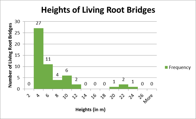
The graph above shows that 38 out of 54, or about 70% of bridges included in this study are between 2 and 6 m in height, with the remaining 30% widely dispersed between 6 and 24 m. Additionally, exactly half of the entries are in the narrow range of 2 to 4 meters in height. In general, it can be said root bridges with heights of over 10 meters are rare.
Interestingly, the data show frequencies of bridges falling off to zero between 2 and 12 m, remaining at zero from 12 to 18 m, and then having a slight rebound between 18 and 24 m. There is one living root bridge, designated Maushuit/Nongbah 1, which, while exact measurements could not be taken due to hazardous conditions, is estimated to be within the range 20-25 m in height. If this trend is still present with the addition of significantly more entries, it may indicate that the survivability of root bridges increases slightly after a certain height, perhaps because at that point stream flooding conditions are no longer a factor.
ALTITUDE:
Altitudes have been calculated by pin-pointing each entry’s GPS position on Google Earth and using that to estimate the position’s altitude. The figures should be taken as estimates. Figures are in meters.
NUMBER OF ALTITUDES OF STANDING BRIDGES MEASURED: 71 (54 STANDING, 17 FAILED)
AVERAGE ALTITUDE (STANDING): 623 m
AVERAGE ALTITUDE (ALL ENTRIES): 572 m
HIGHEST ALTITUDE BRIDGE: 1211 m (Rangthylliang 1)
LOWEST ALTITUDE BRIDGE (STANDING): 57 m (Darang 1)
LOWEST ALTITUDE BRIDGE (FAILED): 38 m (Darang 2)
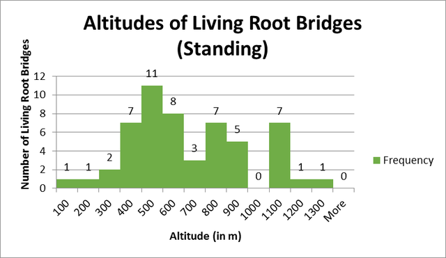
The graph above shows that Living Root Bridges below an altitude of 300 and above an altitude of 1100 are rare within the sample taken. It should be noted that every entry measured at 1000 m or above occurred in the Rangthylliang area, where there is a very high density of surviving living architecture. If other villages in the vicinity have a similar concentration of living root bridges, structures above 1000 m might be more common than this study suggests. However, roughly 75% of the entries fall between 300 and 900 m, and these examples are much more evenly distributed across the area surveyed, suggesting that the majority of living root bridges probably fall within this range of altitudes.
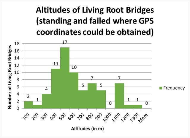
With the addition of 17 more altitudes derived from the positions of living root bridges which have failed but can still be mapped with GPS, the average altitude decreases by about 50 m. Most of the failed bridges occurred in the same range of altitudes as the majority of living root bridges which are still standing. There is however some evidence to suggest that there was once a significant number of living root bridges in the Rangthylliang area which failed around 30 years ago, however it was impossible to determine their exact locations and altitudes.
SURVIVAL RATING:
The Survival Rating (SR), is an estimation of the likelihood that any given standing living root bridge will fail within the next 15 years if the present discernible trends continue. Each structure is given a rating of 1-10, with 1 being a structure where failure during the time period is overwhelmingly likely and 10 being a structure where it is highly improbable. It is an unavoidably subjective way of interpreting the available information, and should only be viewed as a general indicator of the status of a given structure. Others with more time and additional resources might be able to devise a more precise way of gauging the health of living root structures, and their findings might differ somewhat from mine. That being said, I am confident that the overall trends revealed by the SR metric are accurate.
Note that the SR is not an aesthetic judgement of the root bridge being rated. Some of the most scenic root bridges receive a relatively low SR due to the presence of demonstrable threats.
The SR takes three groups of factors into account:
1: How well established and healthy are the roots that make up the bridge in question?
Living root bridges famously self-strengthen as their component roots grow. This means that, assuming the tree the bridge is made from is healthy and the structure is being taken care of, an older root bridge is stronger, and therefore more resilient to possible environmental dangers, than a younger one. This manifests itself in the “wobbliness” of a given root bridge. In crossing an old, healthy, well-established root bridge, there will be no motion in the component roots. For this reason, if comparing a young root bridge with thin roots to an older one with well-established roots, assuming all other survival factors are equal, the older bridge would receive the higher SR.
The SR must also take into account whether or not the organism as a whole appears healthy. In some cases, older root bridges, due to age, poor growth, or manmade or natural environmental factors, will manifest clear signs of decay which will negatively affect the SR.
2: How much physical damage is evident on the bridge in question and on the organism as a whole, and what is the likelihood that the organism will either continue to be damaged or be damaged in the future?
For the purposes of this survey, I’ve grouped sources of physical damage into two categories: 1: Direct manmade threats and 2: Indirect environmental threats.
Direct manmade damage is frequently observed on living root bridges outside of tourist zones. The most common variety of manmade damage, which is present on a majority of living root bridges, is cuts being taken out of the ficus elastica organism in order to harvest the white latex which occurs inside the plant. The latex is said to have a number of local uses, including as an adhesive in animal traps. It is also harvested and sold. While in some cases the cutting is limited to a few shallow gashes on the outside of the organism, in others the cutting is so extreme that it has adversely impacted the strength of the component roots and the health of the organism as a whole. Heavy latex extraction cutting makes any given living root bridge more susceptible to a variety of environmental threats. The presence of numerous latex extraction cuts lowers the bridge’s SR.
Overuse by tourists is another possible direct threat to living root bridges, particularly in the case of younger, less well established bridges, which could conceivably fail if too many tourists stood on one at the same time. Fire damage due to cigarettes or cooking fires that got out of hand might also be caused by tourists.
Environmental damage can be the result of either natural or man-made processes. The most common reason for a root bridge to fall is because of damage sustained during floods and landslides, which are common in the steep terrain of the Khasi and Jaintia Hills. Landslides are said to be more common where the slopes in question have become deforested. Road building can also cause landslides by destabilizing hillsides. Flood conditions on a particular stream can change over time, and streams that were at one time conducive to growing living root architecture can become unsuitable. Shifting cultivation fires can also pose a threat to living architecture, both directly due to fires getting out hand and burning living root bridges, and because of the negative impact of shifting cultivation fires on the stability of hill slopes.
If direct environmental damage is present, or there is solid evidence to indicate that a root bridge is likely to be damaged in the future, the SR is lowered.
3: What is the degree to which local communities are invested in the upkeep of a given root bridge?
Living root bridges that are being actively maintained and protected by their local communities tend to be in much better condition than those which are abandoned or see only limited use.
Often, root bridges that have not been subjected to latex extraction cutting have only been spared because local village councils have specifically outlawed the practice in order to protect the bridge.
While the roots of a living root bridge will continue to grow without maintenance, it is only by the deliberate strengthening of the structure though the strategic placement of pliable younger roots that a given structure will reach its maximum strength and usefulness.
When there is a high degree of community investment in the upkeep of a given root bridge, the bridge has a greater chance of survival because its structural components are being actively strengthened, adding to its resilience to environmental threats, and it’s also being protected from direct manmade damage.
If there is evidence of significant community investment in a particular root bridge, which can be in the form of anecdotal evidence, the existence of heritage or tourism societies, or physical signs of recent upkeep, that positively effects a root bridge’s SR rating. If two root bridges have otherwise identical survival factors, but one is being actively maintained and another is abandoned, the abandoned bridge will have the lower SR rating.
SR KEY:
The following is a rough guide to what specific SR numbers mean.
SR 10-7: Failure appears unlikely. 10 means that, with the available evidence, no argument can be constructed that the bridge might fail in the next 15 years, other than through random incidents such as large earthquakes, or other severe changes in the current trends. A 7 indicates that failure is still highly unlikely, but a case can be made that moderate threats are present.
SR 6-4: Failure or survival is likely. At a 6 the body of evidence still points to the survival of the structure in question in 15 years, but significant threats to its survival can be identified. At a 5, the evidence suggests that there is a roughly equal chance that the root bridge in question will survive or be destroyed. At 4, a strong argument can be made that the bridge could survive if current trends continue, but the evidence indicates that there is a more than 50% chance that it will fail.
SR 3-1: Failure is significantly more likely than survival. An SR of 3 indicates that, while the body of evidence points to failure, an argument can still be made that the bridge could survive. At 1, the root bridge appears nearly certain to fail.
AMOUNT OF STRUCTURES GIVEN SR NUMBERS: 53
AVERAGE SR: 5
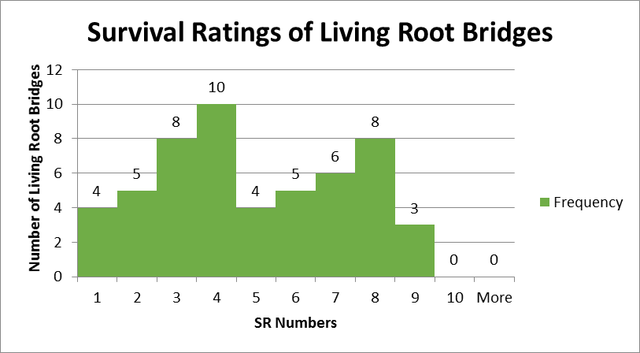
Note that of 53 root bridges included in this survey, significant survival issues can be found with 36, or approximately 70% of the total. About 30% of the bridges included in the study fall within the range SR 1-3, and can be considered very likely to fail within the next 15 years. The same number, 30%, fall within the range SR 7-10, and can considered relatively safe. A plurality fall within the “go either way” category, however an SR of 4 is around twice as likely as a 5 or 6.
During the survey, I did not find any root bridge that could be classed as a 10, or entirely threat free (other than from unpredictable contingencies). That does not mean that root bridges with a 10 rating cannot exist, but they do seem to be very rare. It is, however, much easier to predict that a root bridge will definitely fail than that it will definitely survive.
NOTE: LIVING ROOT BRIDGES UNDER CONSTRUCTION
Perhaps the strongest single indicator of the decline of the practice of creating living root architecture in Meghalaya is the lack of living root bridges that have been recently planted. Entire living root bridges that have only lately been conceived, which are not yet fully functional and where the actual methods of creating new living architecture are currently being employed, are very rare. This is especially true if one discounts examples of newly created living root bridges that are being made specifically for the purposes of tourism or heritage value rather than for practical reasons.
Over the course of this survey, I have found only a single example of a living root bridge outside of a tourist zone that was (probably!) first conceived less than five years ago, and only recently became functional.
This survey includes three examples of entirely newly generated bridges that have yet to become functional. Of these, two are very close to each other, in the village of Nongthymmai. They are part of the Nongriat tourism zone, and are being maintained for tourism purposes. The other, located in Rangthyllaing Village, appears to have been created less than five years ago, making it the newest known living root bridge outside of a tourism zone. However, information concerning the bridge is not entirely consistent: One source from Ranghtylliang claims the bridge has been there for many decades, and only looks new because of poor soil quality causing it to grow very slowly.
The survey also includes three double living root bridges where a new span is being generated. Two of these are in the Nongriat tourist zone, where the Nongriat Double Decker is being made into a triple decker, and another adjacent bridge is being made into a new Double Decker. These have both been created for tourism purposes. A new span is just beginning to be generated on the bridge designated Kudeng Rim 2. The information is not clear as to whether this has been made for functional or tourism purposes.
While the primary root of the bridge Rangthylliang/Mawkyrnot 1 appears to be old and well established, significant new structures are being added to the bridge using bamboo, areca palm trunks, and steel wires. This has been done for tourism/heritage purposes. Another bridge, Pdei/Kongtim 1, again consists of a single old and well established root that has new additions.
A new bridge is being planned by the village of Sohkmi, though, at the time of writing, I am not aware of any work having been done.
There are several bridges where new roots are being trained onto them as part of limited maintenance measures.
