
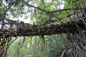
| RIVER/STREAM: | WAH SHENG PNAR |
| LENGTH: | 10.4 m |
| WIDTH AT CP: | 1.7 m |
| HEIGHT AT CP: | 3.2 m |
| GPS: | N25.20516 E92.01889 |
| ALTITUDE: | 57 m |
| SR: | 3 |
| NOTES: | A small root bridge near Darrang village. The path it serviced has been effectively bypassed by a newly constructed road, and has faded in several spots. Several sections of the bridge have been washed out in floods, and there is significant damage. |
NOTE: PLEASE GO TO ANALYTICS AND ANALYSIS (APRIL 2017 DRAFT) FOR METHODOLOGIES. LR PROJECT DESIGNATION DOES NOT REFLECT LOCAL NAME.

The span of Darrang 1, looking north.

Darrang 1, viewed from downstream. Note damage to the railings. Also, note the rocks embedded in the structure to form a walkway.

Darrang 1.

Darrang 1, viewed from upstream.

Darrang 1, viewed from upstream.

The span of Darrang 1.

The span of Darrang 1.
