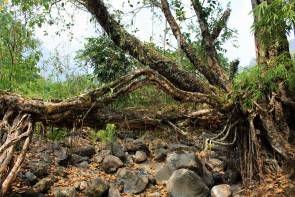
| RIVER/STREAM: |
WAH UMSHET |
| LENGTH: |
10 m |
| WIDTH AT CP: |
.8 m |
| HEIGHT AT CP: |
2.9 m |
| GPS: |
N25.27781 E91.74971 |
| ALTITUDE: |
495 m |
| SR: |
3 |
| NOTES: |
| An old living root bridge with thick roots. The river it was grown over changed course about 20 years ago due to a landslide. Now the bridge is only over water when there are flood conditions. The bridge is still structurally sound, but both the span and the tree are badly damaged by severe latex extraction cutting, which was observed to have markedly increased from 2015 to 2016. The Tree does not appear healthy. Village interest in maintenance is limited, as the bridge is usually not necessary to cross the now dry stream bed. |
|
NOTE: PLEASE GO TO ANALYTICS AND ANALYSIS (APRIL 2017 DRAFT) FOR METHODOLOGIES. LR PROJECT DESIGNATION DOES NOT REFLECT LOCAL NAME.
")
Nongpriang 3 span

Nongpriang 3

Nongpriang 3
This slideshow requires JavaScript.
Like this:
Like Loading...

