
| RIVER/STREAM: | UNKNOWN |
| LENGTH: | 14 m |
| WIDTH AT CP: | 1.2 m |
| HEIGHT AT CP: | 5 m |
| GPS: | N25.24808 E91.63512 |
| ALTITUDE: | 443 m |
| SR: | 2 |
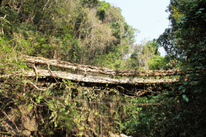
| NOTES: | A heavily damaged living root bridge. The whole left portion of the structure has been destroyed, and the bridge is only usable with the addition of bamboo or wood planks. An attempt seems to have been made to replace the root bridge with a conventional steel wire bridge, though the steel bridge is also damaged and is now unusable. Severe latex extraction damage. The tree is clearly not in good health. A few newly trained young roots were in evidence in 2016, indicating that there might be some community interest in the bridge’s upkeep. |
NOTE: PLEASE GO TO ANALYTICS AND ANALYSIS (APRIL 2017 DRAFT) FOR METHODOLOGIES. LR PROJECT DESIGNATION DOES NOT REFLECT LOCAL NAME.
")
Looking south along the span of Tynrong 1, showing that the bridge only has one railing.
