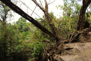
NONGSTENG 2

IMG_1050

RIVER/STREAM: RYNSEIT
GPS: N25.27709 E91.63076
ALTITUDE: 367 m
NOTES: Here, a root bridge that is said to have failed around 20 years ago due to increasing numbers of rocks being brought down in floods on the Rynseit. A few roots are being grown along the replacement conventional structure. That structure, however, is also said to be in danger of being washed out.
NOTE: PLEASE GO TO ANALYTICS AND ANALYSIS (APRIL 2017 DRAFT) FOR METHODOLOGIES. LR PROJECT DESIGNATION DOES NOT REFLECT LOCAL NAME.

Leave a Reply

Fill in your details below or click an icon to log in:

WordPress.com Logo

You are commenting using your WordPress.com account. Log Out /  Change )

Google photo

You are commenting using your Google account. Log Out /  Change )

Twitter picture

You are commenting using your Twitter account. Log Out /  Change )

Facebook photo

You are commenting using your Facebook account. Log Out /  Change )

Connecting to %s