LAITIAM 3

IMG_1415
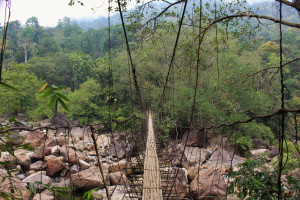
A bridge crossing the Um Jri River next to the remnants of Laitiam 3.
RIVER/STREAM: UM JRI
GPS: N25.23110 E91.75935
ALTITUDE: 316 m
NOTES: An attempt was made here to create a root bridge across the Um Jri. There are clear remnants of a root bridge that crossed from the northern bank of the river to an island, spanning about 20 m. See photos below. Another span was attempted from the island to the southern shore, which would have spanned approximately 60 m. The headman of Laitiam village is unsure if this other span ever became operational, though he suspects that it probably did not due to its length. The combined spans of the planned root bridge would have been around 80 m, or significantly longer than any known surviving example.
NOTE: PLEASE GO TO ANALYTICS AND ANALYSIS (APRIL 2017 DRAFT) FOR METHODOLOGIES. LR PROJECT DESIGNATION DOES NOT REFLECT LOCAL NAME.

Leave a Reply

Fill in your details below or click an icon to log in:

WordPress.com Logo

You are commenting using your WordPress.com account. Log Out /  Change )

Google photo

You are commenting using your Google account. Log Out /  Change )

Twitter picture

You are commenting using your Twitter account. Log Out /  Change )

Facebook photo

You are commenting using your Facebook account. Log Out /  Change )

Connecting to %s