
NONGRIAT 1
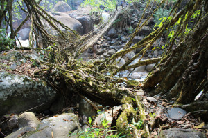
| RIVER/STREAM: | WEITUNG |
| LENGTH: | 7.6 m |
| WIDTH AT CP: | 1.8 m |
| HEIGHT AT CP: | 2.8 m |
| GPS: | N25.25766 E91.67554 |
| ALTITUDE: | 417 m |
| SR: | 8 |
| NOTES: | A small living root bridge in a cluster of botanical architecture north of Nongriat Village. The primary roots are old and well established. Signs of recent upkeep and maintenance. Very old latex extraction cuts are in evidence. There is community interest in upkeep due to tourism. Damaging the bridge is now outlawed. There is a possibility of unscrupulous tourists damaging bridge. |
Note: Please go to Analytics and Analysis (April 2017 Draft) for methodologies. LR Project designation does not reflect local name.
")
Nongriat 1 (background, crossing stream), during the monsoon season of 2012.

Nongriat 1
